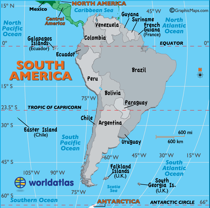
Monday, September 23, 2019

South America

South America
South America is the world’s fourth largest continent by land area, and the world’s third most populous. It is mostly situated in the southern hemisphere, with the exception of a small area of the northernmost portion of the continent. It is found completely in the western hemisphere. South America is bordered by the Atlantic Ocean in the east, the Pacific Ocean in the west, the Southern Ocean in the south, and North America in the north.
South America’s climate ranges from the dry Andacan Desert to the lush rain forests of the Amazon. The Andean Plateau, which is found atop the Andes Mountains, is the world’s largest plateau outside of Tibet. South America is home to amazing species of flora and fauna, including unique tropical birds and monkeys.
Brazil is the most populated country in South America, followed by Colombia and Argentina. The most popular language in South America is Spanish, although there is a high number of Portuguese speakers due to its status as the official language of Brazil. English is the official language in Guyana, while Dutch is spoken in Suriname.

It is bordered on the west by the Pacific Ocean and on the north and east by the Atlantic OceanNorth America and the Caribbean Sea lie to the northwest. It includes twelve sovereign states (ArgentinaBoliviaBrazilChileColombiaEcuadorGuyanaParaguayPeruSurinameUruguay, and Venezuela), a part of France (French Guiana), and a non-sovereign area (the Falkland Islands, a British Overseas Territory though this is disputed by Argentina). In addition to this, the ABC islands of the Kingdom of the NetherlandsTrinidad and Tobago, and Panama may also be considered part of South America.
South America has an area of 17,840,000 square kilometers (6,890,000 sq mi). Its population as of 2016 has been estimated at more than 420 million.[1] South America ranks fourth in area (after AsiaAfrica, and North America) and fifth in population (after Asia, Africa, Europe, and North America). Brazil is by far the most populous South American country, with more than half of the continent's population, followed by Colombia, Argentina, Venezuela and Peru. In recent decades Brazil has also concentrated half of the region's GDP and has become a first regional power.

Geography

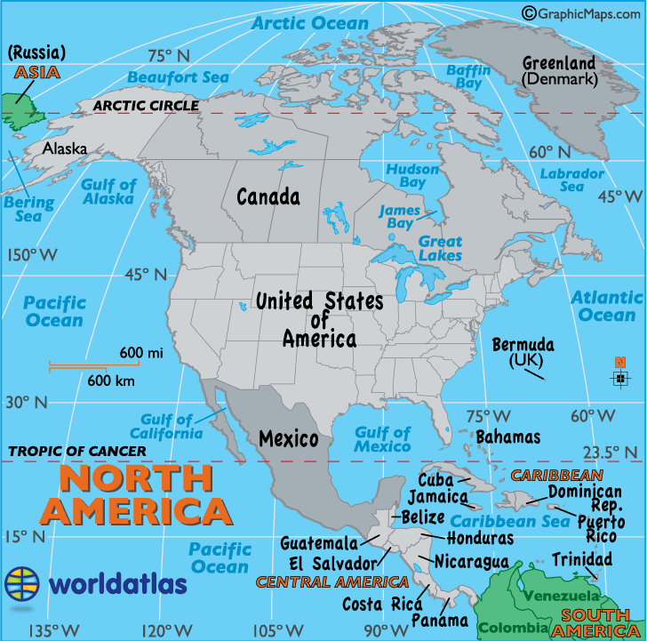
South America occupies the southern portion of the Americas. The continent is generally delimited on the northwest by the Darién watershed along the Colombia–Panama border, although some may consider the border instead to be the Panama CanalGeopolitically and geographically all of Panama – including the segment east of the Panama Canal in the isthmus – is typically included in North America alone and among the countries of Central America. Almost all of mainland South America sits on the South American Plate.
South America is home to the world's highest uninterrupted waterfallAngel Falls in Venezuela; the highest single drop waterfall Kaieteur Falls in Guyana; the largest river by volume, the Amazon River; the longest mountain range, the Andes (whose highest mountain is Aconcagua at 6,962 m or 22,841 ft); the driest non-polar place on earth, the Atacama Desert; the largest rainforest, the Amazon Rainforest; the highest capital city, La Paz, Bolivia; the highest commercially navigable lake in the world, Lake Titicaca; and, excluding research stations in Antarctica, the world's southernmost permanently inhabited community, Puerto Toro, Chile.

History

South America is believed to have been joined with Africa from the late Paleozoic Era to the early Mesozoic Era, until the supercontinent Pangaea began to rift and break apart about 225 million years ago. Therefore, South America and Africa share similar fossils and rock layers.
South America is thought to have been first inhabited by humans when people were crossing the Bering Land Bridge (now the Bering Strait) at least 15,000 years ago from the territory that is present-day Russia. They migrated south through North America, and eventually reached South America through the Isthmus of Panama.
The first evidence for the existence of the human race in South America dates back to about 9000 BC, when squasheschili peppers and beans began to be cultivated for food in the highlands of the Amazon Basin. Pottery evidence further suggests that manioc, which remains a staple food today, was being cultivated as early as 2000 BC.

Politics

Historically, the Hispanic countries were founded as Republican dictatorships led by caudillosBrazil was the only exception, being a constitutional monarchy for its first 67 years of independence, until a coup d'état proclaimed a republic. In the late 19th century, the most democratic countries were BrazilChile, Argentina and Uruguay.
In the interwar period, nationalism grew stronger on the continent, influenced by countries like Nazi Germany and Fascist Italy. A series of authoritarian rules broke out in South American countries with views bringing them closer to the Axis Powers, like Vargas's Brazil. In the late 20th century, during the Cold War, many countries became military dictatorships under American tutelage in attempts to avoid the influence of the Soviet Union. After the fall of the authoritarian regimes, these countries became democratic republics.
During the first decade of the 21st century, South American governments have drifted to the political left, with leftist leaders being elected in Chile, Uruguay, Brazil, Argentina, Ecuador, Bolivia, Paraguay, Peru and Venezuela. Most South American countries are making increasing use of protectionist policies, helping local development.

Economy

South America relies less on the export of both manufactured goods and natural resources than the world average; merchandise exports from the continent were 16% of GDP on an exchange rate basis, compared to 25% for the world as a whole. Brazil (the seventh largest economy in the world and the largest in South America) leads in terms of merchandise exports at $251 billion, followed by Venezuela at $93 billion, Chile at $86 billion, and Argentina at $84 billion.
Since 1930, the continent has experienced remarkable growth and diversification in most economic sectors. Most agricultural and livestock products are destined for the domestic market and local consumption. However, the export of agricultural products is essential for the balance of trade in most countries.
The main agrarian crops are export crops, such as soy and wheat. The production of staple foods such as vegetables, corn or beans is large, but focused on domestic consumption. Livestock raising for meat exports is important in Argentina, Paraguay, Uruguay and Colombia. In tropical regions the most important crops are coffeecocoa and bananas, mainly in Brazil, Colombia and Ecuador. Traditionally, the countries producing sugar for export are Peru, Guyana and Suriname, and in Brazil, sugar cane is also used to make ethanol. On the coast of Peru, northeast and south of Brazil, cotton is grown. Fifty percent of the South American surface is covered by forests, but timber industries are small and directed to domestic markets. In recent years, however, transnational companies have been settling in the Amazon to exploit noble timber destined for export. The Pacific coastal waters of South America are the most important for commercial fishing. The anchovy catch reaches thousands of tons, and tuna is also abundant (Peru is a major exporter). The capture of crustaceans is remarkable, particularly in northeastern Brazil and Chile.

Tourism 

Tourism has increasingly become a significant source of income for many South American countries.
Historical relics, architectural and natural wonders, a diverse range of foods and culture, vibrant and colorful cities, and stunning landscapes attract millions of tourists every year to South America. Some of the most visited places in the region are Iguazu FallsRecifeOlindaMachu PicchuBariloche, the Amazon rainforestRio de JaneiroSão LuísSalvadorFortalezaMaceióBuenos AiresFlorianópolisSan Ignacio MiníIsla MargaritaNatalLimaSão PauloAngel FallsBrasíliaNazca LinesCuzcoBelo HorizonteLake TiticacaSalar de UyuniJesuit Missions of ChiquitosLos Roques archipelagoGran SabanaPatagoniaTayrona National Natural ParkSanta MartaBogotáCaliMedellínCartagenaPerito Moreno Glacier and the Galápagos Islands. In 2016 Brazil hosted the 2016 Summer Olympics.

Culture

South Americans are culturally influenced by their indigenous peoples, the historic connection with the Iberian Peninsula and Africa, and waves of immigrants from around the globe.
South American nations have a rich variety of music. Some of the most famous genres include vallenato and cumbia from Colombia, pasillo from Colombia and Ecuador, sambabossa nova and música sertaneja from Brazil, and tango from Argentina and Uruguay. Also well known is the non-commercial folk genre Nueva Canción movement which was founded in Argentina and Chile and quickly spread to the rest of the Latin America.


Thursday, September 19, 2019

North America

North America

North America is the third largest continent in the world by land area. By population, it is the fourth largest. Sometimes considered to be a subcontinent of the Americas, North America is found entirely in the northern hemisphere and is bordered by the Arctic Ocean in the north, the Atlantic ocean in the east, the Pacific Ocean in the west, and South America to the south. North America is home to the longest land border in the world, which is shared between Canada the the United States.
The climate of North America is warmer in the south of the continent, and colder in the north. While temperatures near the coast tend to be mild, inland temperatures can experience extremes. While the southern portion of the continent, in the southern United States and Central America, is subtropical, the northern portion of the continent consists largely of Arctic tundra.
The United States is the most populated country in North America, followed by Mexico. The people of North America are ethnically diverse. English, Spanish, and French are the most commonly spoken languages on the continent, although there are a number of minority languages as well.

North America covers an area of about 24,709,000 square kilometers (9,540,000 square miles), about 16.5% of the earth's land area and about 4.8% of its total surface. North America is the third largest continent by area, following Asia and Africa, and the fourth by population after Asia, Africa, and Europe. In 2013, its population was estimated at nearly 579 million people in 23 independent states, or about 7.5% of the world's population, if nearby islands (most notably the Caribbean) are included.
North America was reached by its first human populations during the last glacial period, via crossing the Bering land bridge approximately 40,000 to 17,000 years ago. The so-called Paleo-Indian period is taken to have lasted until about 10,000 years ago (the beginning of the Archaic or Meso-Indian period). The Classic stage spans roughly the 6th to 13th centuries. The Pre-Columbian era ended in 1492, with the beginning of the transatlantic migrations—the arrival of European settlers during the Age of Discovery and the Early Modern period. Present-day cultural and ethnic patterns reflect interactions between European colonistsindigenous peoplesAfrican slaves and their descendants.

History

Laurentia is an ancient craton which forms the geologic core of North America; it formed between 1.5 and 1.0 billion years ago during the Proterozoic eon. The Canadian Shield is the largest exposure of this craton. From the Late Paleozoic to Early Mesozoic eras, North America was joined with the other modern-day continents as part of the supercontinent Pangaea, with Eurasia to its east. One of the results of the formation of Pangaea was the Appalachian Mountains, which formed some 480 million years ago, making it among the oldest mountain ranges in the world. When Pangaea began to rift around 200 million years ago, North America became part of Laurasia, before it separated from Eurasia as its own continent during the mid-Cretaceous period. The Rockies and other western mountain ranges began forming around this time from a period of mountain building called the Laramide orogeny, between 80 and 55 million years ago. The formation of the Isthmus of Panama that connected the continent to South America arguably occurred approximately 12 to 15 million years ago, and the Great Lakes (as well as many other northern freshwater lakes and rivers) were carved by receding glaciers about 10,000 years ago.

Geography

North America occupies the northern portion of the landmass generally referred to as the New World, the Western Hemispherethe Americas, or simply America (which, less commonly, is considered by some as a single continent with North America a subcontinent). North America's only land connection to South America is at the Isthmus of Darian/ Isthmus of Panama. The continent is delimited on the southeast by most geographers at the Darién watershed along the Colombia-Panama border, placing almost all of Panama within North America. Alternatively, some geologists physiographically locate its southern limit at the Isthmus of Tehuantepec, Mexico, with Central America extending southeastward to South America from this point. The Caribbean islands, or West Indies, are considered part of North America. The continental coastline is long and irregular. The Gulf of Mexico is the largest body of water indenting the continent, followed by Hudson Bay. Others include the Gulf of Saint Lawrence and the Gulf of California.

Geology

Geologically, Canada is one of the oldest regions in the world, with more than half of the region consisting of precambrian rocks that have been above sea level since the beginning of the Palaeozoic era. Canada's mineral resources are diverse and extensive. Across the Canadian Shield and in the north there are large iron, nickel, zinc, copper, gold, lead, molybdenum, and uranium reserves. Large diamond concentrations have been recently developed in the Arctic, making Canada one of the world's largest producers. Throughout the Shield there are many mining towns extracting these minerals. The largest, and best known, is Sudbury, Ontario. Sudbury is an exception to the normal process of forming minerals in the Shield since there is significant evidence that the Sudbury Basin is an ancient meteorite impact crater. The nearby, but less known Temagami Magnetic Anomaly has striking similarities to the Sudbury Basin. Its magnetic anomalies are very similar to the Sudbury Basin, and so it could be a second metal-rich impact crater. The Shield is also covered by vast boreal forests that support an important logging industry.

Climate

North America is a very large continent which surpasses the Arctic Circle, and the Tropic of Cancer. Greenland, along with the Canadian Shield, is tundra with average temperatures ranging from 10 to 20 °C (50 to 68 °F), but central Greenland is composed of a very large ice sheet. This tundra radiates throughout Canada, but its border ends near the Rocky Mountains (but still contains Alaska) and at the end of the Canadian Shield, near the Great Lakes. Climate west of the Cascades is described as being a temperate weather with average precipitation 20 inches (510 mm). Climate in coastal California is described to be Mediterranean, with average temperatures in cities like San Francisco ranging from 57 to 70 °F (14 to 21 °C) over the course of the year.

Economy

North America's GDP per capita was evaluated in October 2016 by the International Monetary Fund (IMF) to be $41,830, making it the richest continent in the world, followed by Oceania.
Canada, Mexico, and the United States have significant and multifaceted economic systems. The United States has the largest economy of all three countries and in the world. In 2016, the U.S. had an estimated per capita gross domestic product (PPP) of $57,466 according to the World Bank, and is the most technologically developed economy of the three. The United States' services sector comprises 77% of the country's GDP (estimated in 2010), industry comprises 22% and agriculture comprises 1.2%. The U.S. economy is also the fastest growing economy in North America and the Americas as a whole, with the highest GDP per capita in the Americas as well.

Monday, September 16, 2019

Asia Continent

Asia

Asia is the world’s largest continent both by population and by land area. Comprising of 30% of the world’s land area, Asia borders the Pacific Ocean in the east, the Arctic Ocean in the north, the Indian Ocean in the south, and Europe to the west. Around 60% of the world’s population lives in Asia.
Asia has the longest coastline of any continent. The climate of Asia is very diverse, and ranges from arctic to tropical. Throughout the interior of Asia, the climate is mostly dry. The southern and eastern part of the continent is prone to tropical storms called monsoons. Animals that are unique to Asia include the Asian elephant, the Indian Cobra, and the Japanese macaque.
Over four billion people live in Asia. China is the most populated country in Asia, though it is predicted that the population of India will overtake that of China by 2022. Asia is home to some of the world’s most important economic centers including Hong Kong, Tokyo, Shanghai, and Seoul.

In general terms, Asia is bounded on the east by the Pacific Ocean, on the south by the Indian Ocean, and on the north by the Arctic Ocean. The border of Asia with Europe is a historical and cultural construct, as there is no clear physical and geographical separation between them. It is somewhat arbitrary and has moved since its first conception in classical antiquity. The division of Eurasia into two continents reflects East–West cultural, linguistic, and ethnic differences, some of which vary on a spectrum rather than with a sharp dividing line. The most commonly accepted boundaries place Asia to the east of the Suez Canal separating it from Africa; and to the east of the Turkish Straits, the Ural Mountains and Ural River, and to the south of the Caucasus Mountains and the Caspian and Black Seas, separating it from Europe.

History

The history of Asia can be seen as the distinct histories of several peripheral coastal regions: East Asia, South Asia, Southeast Asia and the Middle East, linked by the interior mass of the Central Asian steppes.
The coastal periphery was home to some of the world's earliest known civilizations, each of them developing around fertile river valleys. The civilizations in Mesopotamia, the Indus Valley and the Yellow River shared many similarities. These civilizations may well have exchanged technologies and ideas such as mathematics and the wheel. Other innovations, such as writing, seem to have been developed individually in each area. Cities, states and empires developed in these lowlands.
The central steppe region had long been inhabited by horse-mounted nomads who could reach all areas of Asia from the steppes. The earliest postulated expansion out of the steppe is that of the Indo-Europeans, who spread their languages into the Middle East, South Asia, and the borders of China, where the Tocharians resided. The northernmost part of Asia, including much of Siberia, was largely inaccessible to the steppe nomads, owing to the dense forests, climate and tundra. These areas remained very sparsely populated.

Geography and Climate

Asia is the largest continent on Earth. It covers 9% of the Earth's total surface area (or 30% of its land area), and has the longest coastline, at 62,800 kilometres (39,022 mi). Asia is generally defined as comprising the eastern four-fifths of Eurasia. It is located to the east of the Suez Canal and the Ural Mountains, and south of the Caucasus Mountains (or the Kuma–Manych Depression) and the Caspian and Black Seas. It is bounded on the east by the Pacific Ocean, on the south by the Indian Ocean and on the north by the Arctic Ocean. Asia is subdivided into 48 countries, three of them (Russia, Kazakhstan and Turkey) having part of their land in Europe.
Asia has extremely diverse climates and geographic features. Climates range from arctic and subarctic in Siberia to tropical in southern India and Southeast Asia. It is moist across southeast sections, and dry across much of the interior. Some of the largest daily temperature ranges on Earth occur in western sections of Asia. The monsoon circulation dominates across southern and eastern sections, due to the presence of the Himalayas forcing the formation of a thermal low which draws in moisture during the summer. 

Economy

Asia has the largest continental economy by both GDP Nominal and PPP in the world, and is the fastest growing economic region. As of 2018, the largest economies in Asia are China, Japan, India, Russia, South Korea, Indonesia and Turkey based on GDP in both nominal and PPP. Based on Global Office Locations 2011, Asia dominated the office locations with 4 of the top 5 being in Asia: Hong KongSingaporeTokyo and Seoul. Around 68 percent of international firms have office in Hong Kong.
In the late 1990s and early 2000s, the economies of China and India have been growing rapidly, both with an average annual growth rate of more than 8%. Other recent very-high-growth nations in Asia include IsraelMalaysiaIndonesiaBangladeshPakistanThailandSri LankaVietnamMongoliaUzbekistan and the Philippines, and mineral-rich nations such as KazakhstanTurkmenistanIranBrunei, the United Arab EmiratesQatarKuwaitSaudi ArabiaBahrain and Oman.


Friday, September 13, 2019

Europe Continent

Europe

Europe is the world’s third most populated continent, and the sixth largest continent by land area. Although physically connected to Asia, Europe has historically been considered a separate continent due to cultural and linguistic differences. The Ural and Caucasus Mountains are generally thought to be the eastern boundary of Europe. The other borders of Europe include the Black Sea and the Mediterranean Sea to the south, the Arctic Ocean to the north, and the Atlantic Ocean to the west. Europe is home to more than 10% of the world’s population.
The climate of Europe is largely shaped by the currents of the Atlantic Ocean, which regulate a mild temperature throughout much of the continent’s coastal areas. Throughout the interior of the continent, more extreme temperatures are experienced.
Europe has the world’s second highest population density after Asia. Monaco is the continent’s most densely populated country. Many of the languages spoken in Europe today can trace their origins to the Roman Empire. Germanic and Slavic languages are also spoken. Europe is home to a few countries that are considered to be transcontinental, i.e., in both Europe and Asia. These countries include Turkey, Armenia, Georgia, and Russia. 

Europe is most commonly considered to be separated from Asia by the watershed divides of the Ural and Caucasus Mountains, the Ural River, the Caspian and Black Seas and the waterways of the Turkish Straits. Although the term "continent" implies physical geography, the land border is somewhat arbitrary and has been redefined several times since its first conception in classical antiquity. The division of Eurasia into two continents reflects East-West cultural, linguistic and ethnic differences which vary on a spectrum rather than with a sharp dividing line. The geographic border between Europe and Asia does not follow any state boundaries: TurkeyRussiaAzerbaijanGeorgia and Kazakhstan are transcontinental countriesSpain is also transcontinental in that its main portion is on the Iberian peninsula (Europe) while pockets of Spanish territory are located across the Strait of Gibraltar on North African territory (i.e. mainly MelillaCeuta, and the Canary Islands in the Atlantic Ocean).
Europe covers about 10,180,000 square kilometres (3,930,000 sq mi), or 2% of the Earth's surface (6.8% of land area). Politically, Europe is divided into about fifty sovereign states of which the Russian Federation is the largest and most populous, spanning 39% of the continent and comprising 15% of its population. Europe had a total population of about 741 million (about 11% of the world population) as of 2016. The European climate is largely affected by warm Atlantic currents that temper winters and summers on much of the continent, even at latitudes along which the climate in Asia and North America is severe. Further from the sea, seasonal differences are more noticeable than close to the coast.

Geography

Europe makes up the western fifth of the Eurasian landmass. It has a higher ratio of coast to landmass than any other continent or subcontinent. Its maritime borders consist of the Arctic Ocean to the north, the Atlantic Ocean to the west, and the Mediterranean, Black, and Caspian Seas to the south. Land relief in Europe shows great variation within relatively small areas. The southern regions are more mountainous, while moving north the terrain descends from the high AlpsPyrenees, and Carpathians, through hilly uplands, into broad, low northern plains, which are vast in the east. This extended lowland is known as the Great European Plain, and at its heart lies the North German Plain. An arc of uplands also exists along the north-western seaboard, which begins in the western parts of the islands of Britain and Ireland, and then continues along the mountainous, fjord-cut spine of Norway.

Climate

Europe lies mainly in the temperate climate zones, being subjected to prevailing westerlies. The climate is milder in comparison to other areas of the same latitude around the globe due to the influence of the Gulf Stream. The Gulf Stream is nicknamed "Europe's central heating", because it makes Europe's climate warmer and wetter than it would otherwise be. The Gulf Stream not only carries warm water to Europe's coast but also warms up the prevailing westerly winds that blow across the continent from the Atlantic Ocean.
Therefore, the average temperature throughout the year of Naples is 16 °C (61 °F), while it is only 12 °C (54 °F) in New York City which is almost on the same latitude. Berlin, Germany; Calgary, Canada; and Irkutsk, in the Asian part of Russia, lie on around the same latitude; January temperatures in Berlin average around 8 °C (14 °F) higher than those in Calgary, and they are almost 22 °C (40 °F) higher than average temperatures in Irkutsk. Similarly, northern parts of Scotland have a temperate marine climate. The yearly average temperature in city of Inverses is 9.05 °C (48.29 °F). However, Churchill, Manitoba, Canada, is on roughly the same latitude and has an average temperature of −6.5 °C (20.3 °F), giving it a nearly subarctic climate.

Geology

The geological history of Europe traces back to the formation of the Baltic Shield (Fennoscandia) and the Sarmatian craton, both around 2.25 billion years ago, followed by the Volgo–Uralia shield, the three together leading to the East European craton (≈ Baltica) which became a part of the supercontinent Columbia. Around 1.1 billion years ago, Baltica and Arctica (as part of the Laurentia block) became joined to Rodinia, later resplitting around 550 million years ago to reform as Baltica. Around 440 million years ago Euramerica was formed from Baltica and Laurentia; a further joining with Gondwana then leading to the formation of Pangea. Around 190 million years ago, Gondwana and Laurasia split apart due to the widening of the Atlantic Ocean. Finally, and very soon afterwards, Laurasia itself split up again, into Laurentia (North America) and the Eurasian continent. The land connection between the two persisted for a considerable time, via Greenland, leading to interchange of animal species. From around 50 million years ago, rising and falling sea levels have determined the actual shape of Europe, and its connections with continents such as Asia. Europe's present shape dates to the late Tertiary period about five million years ago.

Politics

The political map of Europe is substantially derived from the re-organisation of Europe following the Napoleonic Wars in 1815. The prevalent form of government in Europe is parliamentary democracy, in most cases in the form of Republic; in 1815, the prevalent form of government was still the Monarchy. Europe's remaining eleven monarchies are constitutional.
European integration is the process of political, legal, economic (and in some cases social and cultural) integration of European states as it has been pursued by the powers sponsoring the Council of Europe since the end of World War II The European Union has been the focus of economic integration on the continent since its foundation in 1993. More recently, the Eurasian Economic Union has been established as a counterpart comprising former Soviet states.
28 European states are members of the politico-economic European Union, 26 of the border-free Schengen Area and 19 of the monetary union Eurozone. Among the smaller European organizations are the Nordic Council, the Benelux, the Baltic Assembly and the Visegrád Group.

Economy

As a continent, the economy of Europe is currently the largest on Earth and it is the richest region as measured by assets under management with over $32.7 trillion compared to North America's $27.1 trillion in 2008. In 2009 Europe remained the wealthiest region. Its $37.1 trillion in assets under management represented one-third of the world's wealth. It was one of several regions where wealth surpassed its precrisis year-end peak. As with other continents, Europe has a large variation of wealth among its countries. The richer states tend to be in the West; some of the Central and Eastern European economies are still emerging from the collapse of the Soviet Union and the breakup of Yugoslavia.
The European Union, a political entity composed of 28 European states, comprises the largest single economic area in the world. 19 EU countries share the euro as a common currency. Five European countries rank in the top ten of the world's largest national economies in GDP (PPP). This includes (ranks according to the CIA): Germany (5), the UK (6), Russia (7), France (8), and Italy (10).
There is huge disparity between many European countries in terms of their income. The richest in terms of GDP per capita is Monaco with its US$172,676 per capita (2009) and the poorest is Moldova with its GDP per capita of US$1,631 (2010). Monaco is the richest country in terms of GDP per capita in the world according to the World Bank report.